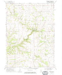
1968 Map of Elizabeth NE
USGS Topo · Published 1970About this map
Apple River Canyon State Park dominates the center of this terrain, where the Apple River and its tributaries have carved deep paths through the Jo Daviess County landscape. The tiny settlement of Millville sits at the northern edge of the canyon, accompanied by the nearby Millville Cem. The map reveals a rural economy shaped by geology and civic duty, with several Quarry sites dotting the hillsides and a local Townhall serving the residents of Rush and Warren townships. Genealogists will find a detailed record of local family history through numerous burial grounds, including St Joseph Cem, Elmwood Cem, and Thompson Cem. The drainage patterns are intricate, featuring named watercourses like Lilly Branch and the South Fork Apple River that converge as they flow toward the high ground of Benton Mound.
Find a feature on this map
28 named features on this map. Tap any name to fly to it.
Don’t see what you’re looking for? This feature index may not catch every label — zoom into the map to look around manually.
Map Details
Editions of this 1968 Elizabeth NE Map
This is the sole edition of this map. No revisions or reprints were ever made.
Other maps of this area

1902 · Mineral Point
USGS Topo · 1:125,000

1911 · Elizabeth
USGS Topo · 1:62,500

1923 · South Wayne
USGS Topo · 1:62,500

1936 · Elizabeth
USGS Topo · 1:62,500

1937 · Lena
USGS Topo · 1:48,000

1942 · Lena
USGS Topo · 1:62,500

1943 · Lena
USGS Topo · 1:62,500

1952 · Shullsburg
USGS Topo · 1:24,000

1954 · Rockford
USGS Topo · 1:250,000

1955 · Rockford
USGS Topo · 1:250,000