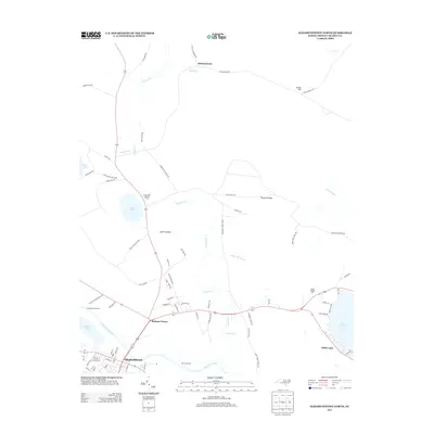
2013 Map of Elizabethtown North
USGS Topo · Published 2013About this map
Elizabethtown and the surrounding Bladen County landscape are defined by the winding course of the Cape Fear River and a series of unique Carolina bay lakes. This 2013 survey details the transition from the riverfront at Browns Landing to the recreational hubs of Jones Lake State Park and the settlement at White Lake. The map illustrates a complex network of local hydrology, where Turnbull Cr and its tributaries like Panther Br drain through low-lying areas such as Thumb Swamp and Smith Swamp.
Find a feature on this map
77 named features on this map. Tap any name to fly to it.
Don’t see what you’re looking for? This feature index may not catch every label — zoom into the map to look around manually.
Map Details
Editions of this 2013 Elizabethtown North Map
This is the sole edition of this map. No revisions or reprints were ever made.
Other maps of this area

1953 · Florence
USGS Topo · 1:250,000

1954 · Florence
USGS Topo · 1:250,000

1954 · White Lake
USGS Topo · 1:62,500

1955 · Elizabethtown
USGS Topo · 1:62,500

1959 · Roseboro
USGS Topo · 1:62,500

1959 · Garland
USGS Topo · 1:62,500

1982 · Elizabethtown
USGS Topo · 1:100,000
1986 · Garland
USGS Topo · 1:24,000
1986 · Singletary Lake
USGS Topo · 1:24,000
1986 · White Lake
USGS Topo · 1:24,000