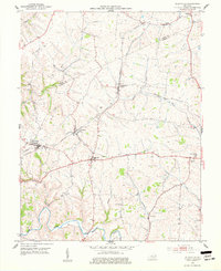
1952 Map of Elizaville
USGS Topo · Published 1977About this map
Elizaville and its surrounding agricultural landscape are defined by the winding course of Fleming Creek and the steel rails of the Louisville and Nashville railroad. Surveyed in the early 1950s, this area on the border of Mason and Fleming Counties shows a dense network of small rural settlements including Ewing, Nepton, and Flemingsburg Junction. The importance of community centers is evident through the naming of local landmarks such as Clover Hill Ch and several family-named burial grounds like Andrews Cem and Jackson Cem.
Find a feature on this map
28 named features on this map. Tap any name to fly to it.
Don’t see what you’re looking for? This feature index may not catch every label — zoom into the map to look around manually.
Map Details
Editions of this 1952 Elizaville Map
3 editions found
Other maps of this area

1915 · Maysville
USGS Topo · 1:62,500

1919 · Maysville
USGS Topo · 1:62,500

1929 · Springdale
USGS Topo · 1:48,000

1935 · Springdale
USGS Topo · 1:62,500

1951 · Hillsboro
USGS Topo · 1:24,000

1951 · Flemingsburg
USGS Topo · 1:24,000

1952 · Cowan
USGS Topo · 1:24,000

1952 · Sherburne
USGS Topo · 1:24,000

1952 · Elizaville
USGS Topo · 1:24,000

1952 · Sardis
USGS Topo · 1:24,000