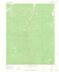
1960 Map of Elk Creek
USGS Topo · Published 1967About this map
Hermosa Park sits at the northern edge of this high-elevation mountain landscape, serving as a focal point for the complex drainage system of the San Juan National Forest. The 1960 field survey reveals a network of watercourses branching from Hermosa Creek, including North Hole Creek and South Hole Creek, which highlight the intricate hydraulic character of the San Juan Mountains. The terrain is defined by its lack of permanent settlements, focused instead on seasonal movement and resource management as evidenced by a Gaging Station and the Highline Trail. The county line between Montezuma and La Plata counties cuts across the northwestern corner, marking a political boundary through the wild drainage basins of Lone Spruce Draw and Corral Draw. This map is particularly valuable for tracing the original alignments of backcountry routes like the Jeep Trail and Pack Trail before modern forest management altered these historic paths.
Find a feature on this map
30 named features on this map. Tap any name to fly to it.
Don’t see what you’re looking for? This feature index may not catch every label — zoom into the map to look around manually.
Map Details
Editions of this 1960 Elk Creek Map
5 editions found


Other maps of this area

1895 · La Plata
USGS Topo · 1:62,500

1897 · La Plata
USGS Topo · 1:62,500

1897 · Rico
USGS Topo · 1:62,500

1898 · Durango
USGS Topo · 1:62,500

1898 · Engineer Mountain
USGS Topo · 1:62,500

1898 · Rico
USGS Topo · 1:62,500

1899 · La Plata
USGS Topo · 1:62,500

1899 · Rico
USGS Topo · 1:62,500

1900 · Engineer Mountain
USGS Topo · 1:62,500

1907 · Durango
USGS Topo · 1:62,500