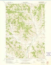
1973 Map of Elk Creek
USGS Topo · Published 1975About this map
Chimney Rock State Public Hunting Grounds and Borst Valley State Public Hunting Grounds dominate the northern and central sections of this Trempealeau County landscape. The terrain is deeply carved by a network of drainage systems, including Chimney Rock Creek, Johnson Valley, and Traverse Valley Creek. These coulees and ridges dictate the placement of rural homes and farmsteads, particularly around the small community of Elk Creek and the settlement at Hawkinson.
Find a feature on this map
30 named features on this map. Tap any name to fly to it.
Don’t see what you’re looking for? This feature index may not catch every label — zoom into the map to look around manually.
Map Details
Editions of this 1973 Elk Creek Map
This is the sole edition of this map. No revisions or reprints were ever made.
Other maps of this area

1926 · Whitehall
USGS Topo · 1:62,500

1927 · Strum
USGS Topo · 1:62,500

1929 · Whitehall
USGS Topo · 1:62,500

1930 · Strum
USGS Topo · 1:62,500

1932 · Gilmanton
USGS Topo · 1:62,500

1932 · Mondovi
USGS Topo · 1:62,500

1953 · Eau Claire
USGS Topo · 1:250,000

1958 · Eau Claire
USGS Topo · 1:250,000

1964 · Eau Claire
USGS Topo · 1:250,000
1973 · Strum SE
USGS Topo · 1:24,000