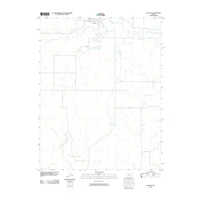
2009 Map of Elk Falls
USGS Topo · Published 2009About this map
Elk Falls sits at the northern edge of this Elk County landscape, defined by a dense network of meandering waterways and section-line roads. The Elk River flows eastward from the town site, joined by tributaries including Wildcat Creek and Clear Creek. To the south, the terrain is segmented by numerous drainage systems, most notably South Salt Creek and North Caney Creek, which create a complex riparian geography across the rural acreage. The mapping shows a strictly organized grid of local transit routes, with named corridors such as Valley Rd and Trail Rd providing access to the interior. The spatial arrangement of small farm ponds and drainage patterns across these sections reflects the agricultural character of southeastern Kansas as it entered the 21st century, maintaining the traditional township and range divisions established over a century prior.
Find a feature on this map
24 named features on this map. Tap any name to fly to it.
Don’t see what you’re looking for? This feature index may not catch every label — zoom into the map to look around manually.
Map Details
Editions of this 2009 Elk Falls Map
This is the sole edition of this map. No revisions or reprints were ever made.
Other maps of this area

1885 · Sedan
USGS Topo · 1:125,000

1889 · Sedan
USGS Topo · 1:125,000

1955 · Wichita
USGS Topo · 1:250,000

1958 · Wichita
USGS Topo · 1:250,000
1962 · Oak Valley
USGS Topo · 1:24,000

1962 · Moline
USGS Topo · 1:24,000
1962 · Elk Falls
USGS Topo · 1:24,000

1962 · Sedan
USGS Topo · 1:24,000

1962 · Elgin NE
USGS Topo · 1:24,000
1962 · Hale
USGS Topo · 1:24,000