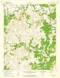
1962 Map of Oak Valley
USGS Topo · Published 1963About this map
Elk River winds through the northern reaches of this landscape, carving a valley that defines the local economy and settlement patterns in the early 1960s. The town of Longton stands as a primary hub, featuring a Fairground and a Pumping Station, while the Atchison Topeka and Santa Fe River railroad line tracks the river's path toward the village of Oak Valley. This survey captures the rural character of the border between Elk and Chautauqua Counties, where the terrain transitions from the broad river bottom to the dissected uplands of Lafayette and Salt Creek townships.
Find a feature on this map
22 named features on this map. Tap any name to fly to it.
Don’t see what you’re looking for? This feature index may not catch every label — zoom into the map to look around manually.
Map Details
Editions of this 1962 Oak Valley Map
2 editions found
Other maps of this area

1885 · Sedan
USGS Topo · 1:125,000

1886 · Independence
USGS Topo · 1:125,000

1889 · Sedan
USGS Topo · 1:125,000

1894 · Independence
USGS Topo · 1:125,000

1905 · Independence
USGS Topo · 1:125,000

1947 · Joplin
USGS Topo · 1:250,000

1949 · Joplin
USGS Topo · 1:250,000

1954 · Joplin
USGS Topo · 1:250,000

1955 · Wichita
USGS Topo · 1:250,000

1958 · Wichita
USGS Topo · 1:250,000