
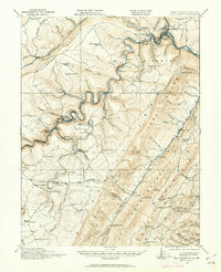
1919 Map of Elk Garden
USGS Topo · Published 1919About this map
The Potomac River carves a winding path along the state line in this survey of Mineral and Grant Counties, where the mountain topography dictated the growth of rail-dependent settlements. The Western Maryland Railway and Baltimore and Ohio Railroad track the river's edge, serving industrial outposts like Piedmont, Beryl, and Potomac Manor. This era shows a dense network of rural infrastructure, including numerous one-room schoolhouses such as the Terra Firma School, Empire School, and Hampshire School that once dotted the highlands.
Find a feature on this map
89 named features on this map. Tap any name to fly to it.
Don’t see what you’re looking for? This feature index may not catch every label — zoom into the map to look around manually.
Map Details
Editions of this 1919 Elk Garden Map
2 editions found
Other maps of this area

1891 · Romney
USGS Topo · 1:125,000

1895 · Piedmont
USGS Topo · 1:125,000

1898 · Frostburg
USGS Topo · 1:62,500

1899 · Grantsville
USGS Topo · 1:62,500

1899 · Oakland
USGS Topo · 1:62,500

1900 · Accident
USGS Topo · 1:62,500

1900 · Oakland
USGS Topo · 1:62,500

1901 · Frostburg
USGS Topo · 1:62,500

1904 · Grantsville
USGS Topo · 1:62,500

1908 · Frostburg
USGS Topo · 1:62,500