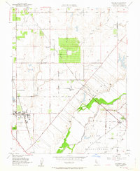
1952 Map of Elk Grove
USGS Topo · Published 1963About this map
Elk Grove and the surrounding agricultural landscapes of Sacramento County appear here during a period of steady post-war transition. The town's historic core is anchored by the Southern Pacific railroad and the Union High Sch, while a Winery and the Central Valleys State Fish Hatchery highlight the local economic reliance on land and water resources. The geography is defined by the sweeping Cosumnes River and its accompanying Grant Boundary, which marks the edge of the San Jon de los Moquelumnes land grant.
Find a feature on this map
42 named features on this map. Tap any name to fly to it.
Don’t see what you’re looking for? This feature index may not catch every label — zoom into the map to look around manually.
Map Details
Editions of this 1952 Elk Grove Map
3 editions found
Other maps of this area

1891 · Sacramento
USGS Topo · 1:125,000

1892 · Sacramento
USGS Topo · 1:125,000

1893 · Sacramento
USGS Topo · 1:125,000

1894 · Lodi
USGS Topo · 1:125,000

1902 · Fairoaks
USGS Topo · 1:62,500

1908 · Buffalo Creek
USGS Topo · 1:31,680

1909 · Elk Grove
USGS Topo · 1:31,680

1909 · Clay
USGS Topo · 1:31,680

1909 · Cosumnes
USGS Topo · 1:31,680

1909 · Florin
USGS Topo · 1:31,680