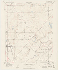
1952 Map of Elk Grove
USGS Topo · Published 1963About this map
Elk Grove and its surrounding agricultural landscape are captured in this mid-century survey, defined by the intersection of the Southern Pacific railroad and a grid of rural roads like Florin Road and Grant Line Road. The town core includes Union High Sch, a Winery, and the Elk Grove Park, while the broader terrain is marked by family-named schools such as Reese School and the Dillard Sch.
Find a feature on this map
38 named features on this map. Tap any name to fly to it.
Don’t see what you’re looking for? This feature index may not catch every label — zoom into the map to look around manually.
Map Details
Editions of this 1952 Elk Grove Map
3 editions found
Other maps of this area

1891 · Sacramento
USGS Topo · 1:125,000

1892 · Sacramento
USGS Topo · 1:125,000

1893 · Sacramento
USGS Topo · 1:125,000

1894 · Lodi
USGS Topo · 1:125,000

1902 · Fairoaks
USGS Topo · 1:62,500

1908 · Buffalo Creek
USGS Topo · 1:31,680

1909 · Elk Grove
USGS Topo · 1:31,680

1909 · Clay
USGS Topo · 1:31,680

1909 · Cosumnes
USGS Topo · 1:31,680

1909 · Florin
USGS Topo · 1:31,680