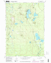
1963 Map of Elk Lake
USGS Topo · Published 1981About this map
The headwaters of the Deschutes River emerge from Little Lava Lake, anchoring a landscape shaped by volcanic activity and alpine hydrology. This survey, updated from earlier mid-century field work, documents a transition in land use as the high Cascades became a focal point for recreation. Established infrastructure like the Guard Sta at Elk Lake and the Sunset View Picnic Area sit alongside geological landmarks such as Red Crater and the Cinder Pit. The map traces the essential north-south corridor of the Cascade Lakes Highway, providing access to numerous water bodies including Hosmer Lake and Doris Lake. For those interested in the history of the backcountry, the presence of the Oregon Skyline Trail and the Metolius-Windigo Trail illustrates the legacy of the Three Sisters Wilderness and its surrounding national forests.
Find a feature on this map
52 named features on this map. Tap any name to fly to it.
Don’t see what you’re looking for? This feature index may not catch every label — zoom into the map to look around manually.
Map Details
Editions of this 1963 Elk Lake Map
4 editions found
Other maps of this area

1929 · Three Sisters
USGS Topo · 1:125,000

1930 · Maiden Peak
USGS Topo · 1:125,000

1932 · Three Sisters
USGS Topo · 1:125,000

1934 · Maiden Peak
USGS Topo · 1:125,000

1955 · Crescent
USGS Topo · 1:250,000

1955 · Bend
USGS Topo · 1:250,000

1957 · Crescent
USGS Topo · 1:250,000

1957 · Bend
USGS Topo · 1:250,000

1958 · Crescent
USGS Topo · 1:250,000

1958 · Bend
USGS Topo · 1:250,000