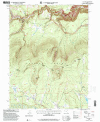
1996 Map of Elk Park
USGS Topo · Published 2000About this map
Ashley National Forest dominates this landscape in the northeastern corner of Utah, where the High Uintas meet the canyons of the Green River. The terrain is defined by dramatic elevation changes, rising from the Flaming Gorge in the north toward high alpine meadows and peaks like Trout Creek Peak. The map reveals a complex system of mountain drainage, with Carter Creek and Deep Creek carving through the northern canyons while Trout Creek and North Fork Ashley Creek traverse the southern parks. The intersection of the Flaming Gorge Vernal Highway and the Uinta Highline Trail highlights the area's transition from a remote backcountry to a managed recreation destination. Named meadows and localized "parks" such as Pat Carroll Park, Soldier Park, and Meadow Park suggest a history of seasonal grazing and forest management, while the Oaks Park Reservoir indicates established water infrastructure within the Uinta District.
Find a feature on this map
44 named features on this map. Tap any name to fly to it.
Don’t see what you’re looking for? This feature index may not catch every label — zoom into the map to look around manually.
Map Details
Editions of this 1996 Elk Park Map
This is the sole edition of this map. No revisions or reprints were ever made.
Other maps of this area

1885 · Ashley
USGS Topo · 1:250,000

1906 · Marsh Peak
USGS Topo · 1:125,000

1908 · Marsh Peak
USGS Topo · 1:125,000

1950 · Dyer Mountain
USGS Topo · 1:24,000

1952 · Flaming Gorge
USGS Topo · 1:24,000

1954 · Vernal
USGS Topo · 1:250,000

1958 · Vernal
USGS Topo · 1:250,000

1960 · Vernal
USGS Topo · 1:250,000
1963 · Manila
USGS Topo · 1:24,000
1963 · Leidy Peak
USGS Topo · 1:24,000