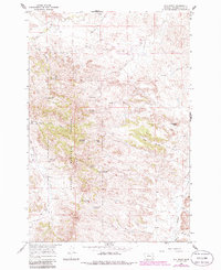
1966 Map of Elk Ridge
USGS Topo · Published 1986About this map
Custer National Forest encompasses the center of this landscape, where the high ground of Elk Ridge serves as a watershed divide for several drainages. The map reveals a cattle-ranching landscape defined by water management, with numerous small impoundments such as Coal Creek Reservoir, Shell Res, John Gold Res, and Elk Ridge Res tucked into the coulees. Evidence of early rural community life is anchored by the Horkan Creek Sch and a lone Cem in the northern reaches, while isolated landmarks like Sandfer Butte provide orientation across the sage-and-grass terrain. The presence of Gold Well, Manning Well, and several other unnamed wells suggests a deep reliance on groundwater to sustain livestock in the dry Powder River country. Navigating the breaks is facilitated by a network of unimproved roads and a Jeep Trail that follows the ridge lines through the forest.
Find a feature on this map
40 named features on this map. Tap any name to fly to it.
Don’t see what you’re looking for? This feature index may not catch every label — zoom into the map to look around manually.
Map Details
Editions of this 1966 Elk Ridge Map
2 editions found
Other maps of this area

1954 · Ekalaka
USGS Topo · 1:250,000

1956 · Ekalaka
USGS Topo · 1:250,000

1958 · Ekalaka
USGS Topo · 1:250,000

1965 · Ekalaka
USGS Topo · 1:250,000

1966 · Stacey
USGS Topo · 1:24,000

1966 · Home Creek Butte
USGS Topo · 1:24,000

1966 · Elk Ridge
USGS Topo · 1:24,000

1966 · Samuelson Ranch
USGS Topo · 1:24,000
1973 · North Stacey School
USGS Topo · 1:24,000

1973 · Box Elder Creek
USGS Topo · 1:24,000