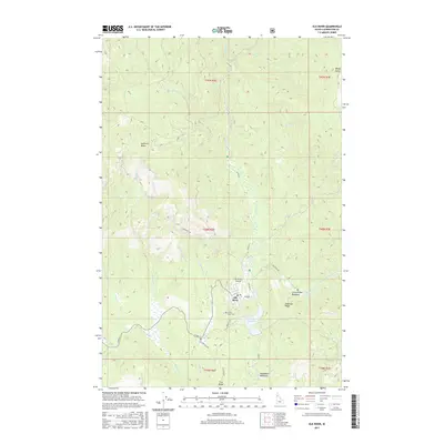
2017 Map of Elk River
USGS Topo · Published 2017About this map
Elk River serves as the primary settlement in this northern Idaho landscape, surrounded by a complex network of forest roads and watercourses. The local infrastructure is anchored by the Elk River Airport and the waters of the Elk Cr Reservoir, while the town itself is situated near the junction of several key routes including Dent Rd and Landing Rd. Genealogists will find the Three Pines Cem located just south of the town center, a significant marker for local family histories.
Find a feature on this map
41 named features on this map. Tap any name to fly to it.
Don’t see what you’re looking for? This feature index may not catch every label — zoom into the map to look around manually.
Map Details
Editions of this 2017 Elk River Map
This is the sole edition of this map. No revisions or reprints were ever made.
Other maps of this area
1955 · Pullman
USGS Topo · 1:250,000
1958 · Pullman
USGS Topo · 1:250,000
1961 · Ahsahka
USGS Topo · 1:62,500
1961 · Bovill
USGS Topo · 1:62,500
1969 · Elk River
USGS Topo · 1:24,000
1969 · Elk Creek Falls
USGS Topo · 1:24,000
1969 · Elk Butte
USGS Topo · 1:24,000
1969 · Anthony Peak
USGS Topo · 1:24,000
1969 · Little Green Mountain
USGS Topo · 1:24,000
1969 · Grice Ridge
USGS Topo · 1:24,000