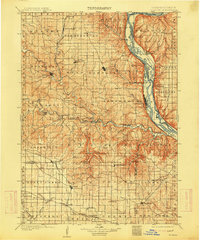
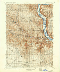
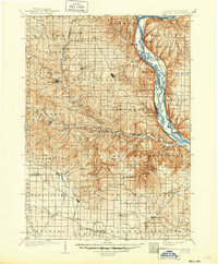
1902 Map of Elkader
USGS Topo · Published 1914About this map
Elkader serves as the focal point of this northeast Iowa landscape, situated along the winding path of the Turkey River. The region’s geography is defined by the massive drainage system of the Mississippi River, which forms the eastern boundary of Clayton County and provides a deep corridor for the Chicago Burlington and Quincy RR. Inland, the terrain is a complex network of ridges and river valleys, where smaller settlements like Garnavillo, Farmersburg, and Guttenberg developed. The map reveals a robust turn-of-the-century infrastructure, with the Chicago Milwaukee and St Paul RR and the Chicago Great Western RR cutting through the uplands to connect rural villages. From the confluence at Turkey River station to the high ground of Patch Grove, this 1902 survey illustrates the vital relationship between the limestone bluffs and the rail lines that fueled early twentieth-century commerce.
Find a feature on this map
101 named features on this map. Tap any name to fly to it.
Don’t see what you’re looking for? This feature index may not catch every label — zoom into the map to look around manually.
Map Details
Editions of this 1902 Elkader Map
4 editions found
Other maps of this area

1900 · Anamosa
USGS Topo · 1:125,000

1900 · Lancaster
USGS Topo · 1:125,000

1901 · Peosta
USGS Topo · 1:125,000

1901 · Oelwein
USGS Topo · 1:125,000

1902 · Elkader
USGS Topo · 1:125,000

1903 · Waukon
USGS Topo · 1:125,000

1903 · Winthrop
USGS Topo · 1:125,000

1904 · Lancaster
USGS Topo · 1:125,000

1906 · Decorah
USGS Topo · 1:125,000

1908 · Lancaster
USGS Topo · 1:125,000