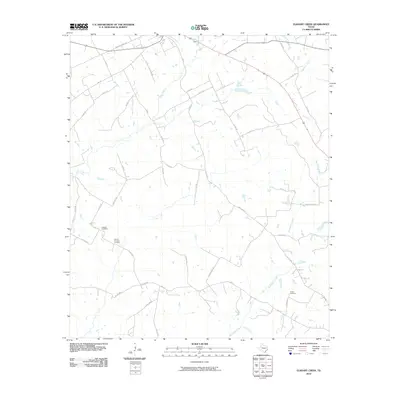
2010 Map of Elkhart Creek
USGS Topo · Published 2010About this map
Big Elkhart Creek and its many tributaries, including Little Creek, Ioni Creek, and Box Creek, define the landscape of this East Texas terrain. The network of local roads reveals a rural settlement pattern deeply rooted in family history, as evidenced by several small burial sites. Genealogists and local historians can find specific landmarks such as Anthom Cemetery, Parker Cemetery, and the Hauser Property Cemetery tucked away from the main thoroughfares. Historic transit routes are still visible through the naming of roads like Bonners Ferry Rd and Old Pilgrim Rd, suggesting older river crossings and pioneer paths. The landscape is primarily divided by county and local roads, including Oak Grove Rd and County Line Rd, which weave around the winding creek beds and low-lying drainages typical of the Anderson County region.
Find a feature on this map
45 named features on this map. Tap any name to fly to it.
Don’t see what you’re looking for? This feature index may not catch every label — zoom into the map to look around manually.
Map Details
Editions of this 2010 Elkhart Creek Map
This is the sole edition of this map. No revisions or reprints were ever made.
Other maps of this area

1951 · Grapeland
USGS Topo · 1:24,000

1951 · Elkhart
USGS Topo · 1:62,500

1952 · Slocum
USGS Topo · 1:62,500

1953 · Palestine
USGS Topo · 1:250,000

1957 · Palestine
USGS Topo · 1:250,000

1964 · Hays Spring
USGS Topo · 1:24,000

1964 · Stanmire Lake
USGS Topo · 1:24,000

1981 · Palestine
USGS Topo · 1:100,000
1982 · Indian Lake
USGS Topo · 1:24,000
1982 · Percilla
USGS Topo · 1:24,000