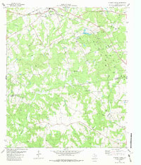
1982 Map of Elkhart Creek
USGS Topo · Published 1982About this map
The Missouri Pacific railroad cuts a diagonal path through this Anderson and Houston County borderlands area, serving as a primary corridor for the rural community of Elkhart. The landscape is characterized by a dense network of watercourses, including Box Creek, Elkhart Creek, and Squirrel Creek, which divide the terrain into low rises and mounds like Rocky Mound. The map reveals a deeply established rural social fabric, evidenced by numerous country churches such as Pilgrim Ch, Rocky Mound Ch, Oak Grove Ch, and Parker Ch. Industrial activity is interspersed throughout the countryside, with frequent Drill Holes, Oil Wells, and a Gas Well indicating significant petroleum exploration. Near the northern boundary, the small settlement of Broom City and the historic Bonners Ferry Road point to older transportation routes that preceded or complemented the heavy rail line.
Find a feature on this map
28 named features on this map. Tap any name to fly to it.
Don’t see what you’re looking for? This feature index may not catch every label — zoom into the map to look around manually.
Map Details
Editions of this 1982 Elkhart Creek Map
This is the sole edition of this map. No revisions or reprints were ever made.
Other maps of this area

1951 · Grapeland
USGS Topo · 1:24,000

1951 · Elkhart
USGS Topo · 1:62,500

1952 · Slocum
USGS Topo · 1:62,500

1953 · Palestine
USGS Topo · 1:250,000

1957 · Palestine
USGS Topo · 1:250,000

1964 · Hays Spring
USGS Topo · 1:24,000

1964 · Stanmire Lake
USGS Topo · 1:24,000

1981 · Palestine
USGS Topo · 1:100,000
1982 · Indian Lake
USGS Topo · 1:24,000
1982 · Percilla
USGS Topo · 1:24,000