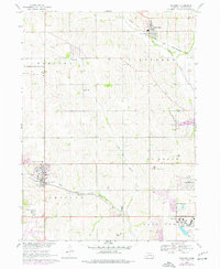
1968 Map of Elkhorn
USGS Topo · Published 1977About this map
St Patricks Seminary and the expanding community of Elkhorn anchor the southwestern portion of this landscape, which transitioned through the late 1960s and 1970s from rural agriculture to residential development. The drainage of Big Papillion Creek and West Papillion Creek dictates the topography, while the Chicago and North Western and Union Pacific railroads define the industrial corridors. To the southeast, the famous campus of Boys Town and the nearby Green Meadows development show the growing footprint of suburban Omaha. Local history is preserved in landmarks such as Flower Hill Cem and Zion Ch, alongside educational relics like Sunny Side Sch and School No 67. An old railroad grade north of Bennington hints at earlier transportation networks that once linked these Douglas County townships.
Find a feature on this map
27 named features on this map. Tap any name to fly to it.
Don’t see what you’re looking for? This feature index may not catch every label — zoom into the map to look around manually.
Map Details
Editions of this 1968 Elkhorn Map
4 editions found
Other maps of this area

1893 · Fremont
USGS Topo · 1:125,000

1896 · Fremont
USGS Topo · 1:125,000

1955 · Fremont
USGS Topo · 1:250,000

1956 · Gretna
USGS Topo · 1:24,000

1956 · Ralston
USGS Topo · 1:24,000

1956 · Irvington
USGS Topo · 1:24,000

1957 · Fremont
USGS Topo · 1:250,000

1958 · Fremont
USGS Topo · 1:250,000

1968 · Valley
USGS Topo · 1:24,000

1968 · Kennard
USGS Topo · 1:24,000