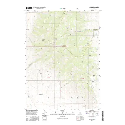
2017 Map of Elkhorn Peak
USGS Topo · Published 2017About this map
Elkhorn Peak and Kents Peak dominate this portion of the Caribou National Forest, marking a high-relief landscape on the border of Bannock and Oneida counties. The geography is defined by a dense network of drainages such as Bill Morgan Canyon and Danish Canyon, which cut through the mountain slopes toward the Malad Valley below. Evidence of early land use and resource management is found in names like Limekiln Canyon and the presence of several isolated water sources including Secret Spring and Bissell Spring. To the south, the terrain softens slightly as the Little Malad River flows near John Evans Canyon Road, while the higher elevations feature the secluded Old Canyon Meadow. This survey highlights the intersection of public forest lands and the rural valley floor, preserving the nomenclature of the area's canyons and hollows.
Find a feature on this map
49 named features on this map. Tap any name to fly to it.
Don’t see what you’re looking for? This feature index may not catch every label — zoom into the map to look around manually.
Map Details
Editions of this 2017 Elkhorn Peak Map
This is the sole edition of this map. No revisions or reprints were ever made.
Other maps of this area
1954 · Pocatello
USGS Topo · 1:250,000
1958 · Pocatello
USGS Topo · 1:250,000
1963 · Daniels
USGS Topo · 1:24,000
1968 · Ireland Springs
USGS Topo · 1:24,000
1968 · Daniels
USGS Topo · 1:24,000
1968 · Malad Summit
USGS Topo · 1:24,000
1968 · Dairy Creek
USGS Topo · 1:24,000
1968 · Malad City West
USGS Topo · 1:24,000
1968 · Downey West
USGS Topo · 1:24,000
1968 · Malad City East
USGS Topo · 1:24,000