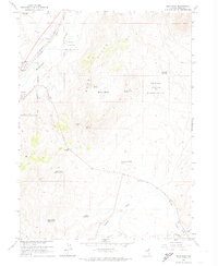
1962 Map of Elko East
USGS Topo · Published 1974About this map
The Humboldt River winds through this Great Basin landscape, serving as a vital corridor for transportation and settlement in northeastern Nevada. During the early 1960s, the eastern outskirts of Elko began to take shape, showing the city's early expansion toward the Humboldt River. The map provides a clear look at the local infrastructure during this period, including the small settlement of Kittridge and the various drainage patterns defined by the local Creek. This area represents a classic example of Nevada's high-desert geography where water sources dictate the placement of human activity and rail lines, reflecting the transition from mid-century ranching roots to a growing regional hub.
Find a feature on this map
4 named features on this map. Tap any name to fly to it.
Don’t see what you’re looking for? This feature index may not catch every label — zoom into the map to look around manually.
Map Details
Editions of this 1962 Elko East Map
Other maps of this area

1952 · Dixie Flats
USGS Topo · 1:62,500

1955 · Elko
USGS Topo · 1:250,000

1957 · Elko West
USGS Topo · 1:24,000

1957 · Elko East
USGS Topo · 1:24,000

1958 · Elko
USGS Topo · 1:250,000

1962 · Elko
USGS Topo · 1:250,000

1962 · Kittridge Springs
USGS Topo · 1:24,000

1962 · Boyd Reservoir
USGS Topo · 1:24,000

1962 · Ryndon
USGS Topo · 1:24,000

1962 · Osino
USGS Topo · 1:24,000