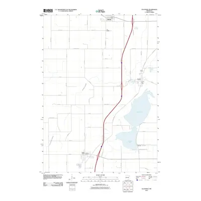
2010 Map of Ellendale
USGS Topo · Published 2010About this map
Geneva Lake dominates the eastern portion of this Freeborn County landscape, serving as a primary hydrological focal point alongside the Straight River and a network of agricultural drainage systems including County Ditch Number Thirty and County Ditch Number Sixtythree. The settlement pattern is defined by the small hubs of Ellendale, Geneva, and Clarks Grove, each centered around its respective post office. This 2010 survey illustrates a highly organized rural grid, where the transition from town to field is sharp and efficient.
Find a feature on this map
35 named features on this map. Tap any name to fly to it.
Don’t see what you’re looking for? This feature index may not catch every label — zoom into the map to look around manually.
Map Details
Editions of this 2010 Ellendale Map
This is the sole edition of this map. No revisions or reprints were ever made.
Other maps of this area

1954 · Albert Lea
USGS Topo · 1:62,500

1954 · Hayward
USGS Topo · 1:62,500

1954 · Mason City
USGS Topo · 1:250,000

1957 · Mason City
USGS Topo · 1:250,000

1958 · Mason City
USGS Topo · 1:250,000

1967 · Steele Center
USGS Topo · 1:24,000

1967 · Hollandale
USGS Topo · 1:24,000
1967 · Hope
USGS Topo · 1:24,000

1967 · Hartland
USGS Topo · 1:24,000

1967 · Ellendale
USGS Topo · 1:24,000