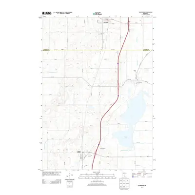
2013 Map of Ellendale
USGS Topo · Published 2013About this map
Geneva Lake dominates the eastern landscape of this Freeborn County region, serving as a focal point for the surrounding agricultural community. The towns of Ellendale, Geneva, and Clarks Grove are connected by a network of rural roads and drainage infrastructure, including County Ditch Number Eight and County Ditch Number Sixtythree, which illustrate the region's managed hydrology. Genealogy researchers will find several local landmarks of interest, such as the First Lutheran Cem located north of the county line and the Clarks Grove Cem situated near the southern settlement. The map also delineates the boundary between Steele and Freeborn counties, following SW 168th St and Co Hwy-14, providing a clear view of the municipal layout as it existed in the early 21st century.
Find a feature on this map
43 named features on this map. Tap any name to fly to it.
Don’t see what you’re looking for? This feature index may not catch every label — zoom into the map to look around manually.
Map Details
Editions of this 2013 Ellendale Map
This is the sole edition of this map. No revisions or reprints were ever made.
Other maps of this area

1954 · Albert Lea
USGS Topo · 1:62,500

1954 · Hayward
USGS Topo · 1:62,500

1954 · Mason City
USGS Topo · 1:250,000

1957 · Mason City
USGS Topo · 1:250,000

1958 · Mason City
USGS Topo · 1:250,000

1967 · Steele Center
USGS Topo · 1:24,000

1967 · Hollandale
USGS Topo · 1:24,000
1967 · Hope
USGS Topo · 1:24,000

1967 · Hartland
USGS Topo · 1:24,000

1967 · Ellendale
USGS Topo · 1:24,000