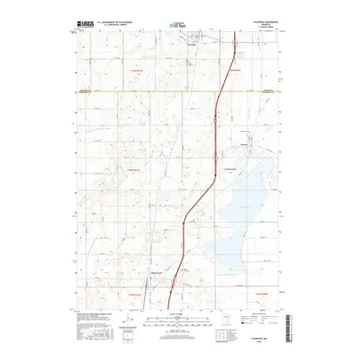
2016 Map of Ellendale
USGS Topo · Published 2016About this map
Geneva Lake dominates the eastern half of this southern Minnesota landscape, serving as a focal point for the surrounding agricultural communities. To the north, Ellendale sits just above the county line, while the town of Geneva borders the lake's western shore. Further south, Clarks Grove serves as a hub for the local farming economy, positioned at a junction of roads and drainage networks. This 2016 survey illustrates the sophisticated water management systems of the region, including County Ditch Number Eight and County Ditch Number Fortysix, which move water across the flat terrain toward the Straight River and Turtle Creek. For those researching local history, the map identifies several significant burial grounds, such as First Lutheran Cem, Geneva Cem, and Clarks Grove Cem, each tied to the early settlement and religious heritage of these tight-knit towns.
Find a feature on this map
72 named features on this map. Tap any name to fly to it.
Don’t see what you’re looking for? This feature index may not catch every label — zoom into the map to look around manually.
Map Details
Editions of this 2016 Ellendale Map
This is the sole edition of this map. No revisions or reprints were ever made.
Other maps of this area
1954 · Albert Lea
USGS Topo · 1:62,500
1954 · Hayward
USGS Topo · 1:62,500
1954 · Mason City
USGS Topo · 1:250,000
1957 · Mason City
USGS Topo · 1:250,000
1958 · Mason City
USGS Topo · 1:250,000
1967 · Steele Center
USGS Topo · 1:24,000
1967 · Hollandale
USGS Topo · 1:24,000
1967 · Hope
USGS Topo · 1:24,000
1967 · Hartland
USGS Topo · 1:24,000
1967 · Ellendale
USGS Topo · 1:24,000