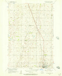
1956 Map of Ellendale North
USGS Topo · Published 1957About this map
The prairie landscape of Dickey County is defined here by the intersection of early transportation and rural education in the mid-1950s. Ellendale serves as the regional hub at the bottom of the map, where the Great Northern railroad terminates and meets the north-south tracks of the Chicago Milwaukee St Paul and Pacific. This rail corridor passes through the small siding of Duane as it cuts across the townships of Keystone, Elden, and Van Meter. Away from the rail lines, the agricultural character of the region is evident in the placement of rural schoolhouses such as Farming Valley Sch No 2 and Farming Valley Sch No 3. The presence of the Ellendale Airport just north of the city limits marks the transition of this Great Plains community into the post-war era of aviation.
Find a feature on this map
12 named features on this map. Tap any name to fly to it.
Don’t see what you’re looking for? This feature index may not catch every label — zoom into the map to look around manually.
Map Details
Editions of this 1956 Ellendale North Map
This is the sole edition of this map. No revisions or reprints were ever made.
Other maps of this area

1894 · Monango
USGS Topo · 1:62,500

1894 · Ellendale
USGS Topo · 1:62,500

1894 · Savo
USGS Topo · 1:62,500

1894 · Fullerton
USGS Topo · 1:62,500

1895 · Lamoure
USGS Topo · 1:125,000

1896 · Columbia
USGS Topo · 1:125,000

1896 · Edgeley
USGS Topo · 1:125,000

1899 · Ellendale
USGS Topo · 1:125,000

1918 · La Moure
USGS Topo · 1:125,000

1925 · Edgeley
USGS Topo · 1:125,000