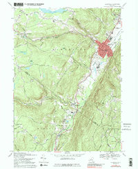
1969 Map of Ellenville
USGS Topo · Published 1989About this map
The Shawangunk Mountains dominate the southeastern landscape of this region, creating a dramatic backdrop for the village of Ellenville. In the late 1960s, this area served as a significant hub in Ulster County, where Rondout Creek and Sandburg Creek converge. The village core is densely detailed with civic infrastructure, including the Municipal Bldg, Library, and the Church of St John. Outside the main settlement, the land transitions into timbered ridges and upland bogs like Pine Swamp and Cedar Swamp. Traces of the region's industrial and transport history are visible in the Hudson Canal Trail and the Delaware and Hudson RR corridor. Local education and community life are anchored by the Ellenville Central Sch and Pine Grove Sch, while the surrounding geography features landmarks such as Hanging Rock Falls and Mt Meenahga.
Find a feature on this map
57 named features on this map. Tap any name to fly to it.
Don’t see what you’re looking for? This feature index may not catch every label — zoom into the map to look around manually.
Map Details
Editions of this 1969 Ellenville Map
3 editions found
Other maps of this area

1903 · Slide Mountain
USGS Topo · 1:62,500

1904 · Ellenville
USGS Topo · 1:62,500

1905 · Slide Mountain
USGS Topo · 1:62,500

1906 · Ellenville
USGS Topo · 1:62,500

1909 · Monticello
USGS Topo · 1:62,500

1910 · Neversink
USGS Topo · 1:62,500

1911 · Monticello
USGS Topo · 1:62,500

1942 · Neversink
USGS Topo · 1:62,500

1942 · Lackawack
USGS Topo · 1:24,000

1942 · Kerhonkson
USGS Topo · 1:24,000