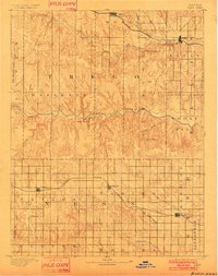
1893 Map of Ellis
USGS Topo · Published 1902About this map
The Smoky Hill River carves through the central portion of this 1891 survey, illustrating the stark topographic contrast between the river's deep drainage and the surrounding high plains. In the north, the Union Pacific Railroad anchors the settlement of Ellis, while the southern expanse is defined by the tracks of the Missouri Pacific Railroad, connecting the small communities of Ransom, Brownell, and Mc Cracken. This landscape of early Kansas rail expansion is marked by distinctive natural landmarks like Round Mound and the steep terrain of Cedar Gorge and Cedar Bluff. The transition from the rugged canyons of Goat Canyon to the wide valleys of Big Creek and Big Timber Creek shows a region undergoing rapid agricultural and transit development, as homesteads and townships began to fill the survey's grid.
Find a feature on this map
35 named features on this map. Tap any name to fly to it.
Don’t see what you’re looking for? This feature index may not catch every label — zoom into the map to look around manually.
Map Details
Editions of this 1893 Ellis Map
4 editions found
Other maps of this area

1889 · Larned
USGS Topo · 1:125,000

1891 · Larned
USGS Topo · 1:125,000

1892 · Ness
USGS Topo · 1:125,000

1893 · Ellis
USGS Topo · 1:125,000

1893 · Hill
USGS Topo · 1:125,000

1894 · Ness
USGS Topo · 1:125,000

1896 · Hays
USGS Topo · 1:125,000

1896 · Plainville
USGS Topo · 1:125,000

1954 · Goodland
USGS Topo · 1:250,000

1955 · Great Bend
USGS Topo · 1:250,000