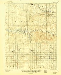
1893 Map of Ellis
USGS Topo · Published 1949About this map
Union Pacific Railroad tracks follow the northern drainage of Big Creek while the Missouri Pacific Railroad carves through the southern townships of Wakeeney and Hampton in this late 19th-century survey. The landscape is defined by the deep incision of the Smoky Hill River, which is flanked by dramatic geological landmarks such as Cedar Bluff, Cedar Gorge, and the uniquely named Round House. These natural features provided vital orientation points for early settlers navigating the high plains between the rail corridors.
Find a feature on this map
34 named features on this map. Tap any name to fly to it.
Don’t see what you’re looking for? This feature index may not catch every label — zoom into the map to look around manually.
Map Details
Editions of this 1893 Ellis Map
4 editions found
Other maps of this area

1889 · Larned
USGS Topo · 1:125,000

1891 · Larned
USGS Topo · 1:125,000

1892 · Ness
USGS Topo · 1:125,000

1893 · Ellis
USGS Topo · 1:125,000

1893 · Hill
USGS Topo · 1:125,000

1894 · Ness
USGS Topo · 1:125,000

1896 · Hays
USGS Topo · 1:125,000

1896 · Plainville
USGS Topo · 1:125,000

1954 · Goodland
USGS Topo · 1:250,000

1955 · Great Bend
USGS Topo · 1:250,000