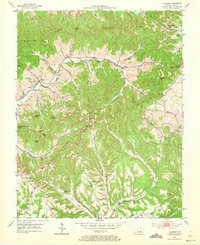
1952 Map of Ellisburg
USGS Topo · Published 1973About this map
The winding valleys and ridges of Casey County define this rural landscape during the early 1950s, centered on the community of Ellisburg. The settlement pattern follows the narrow creek bottoms of the Big South Fork and its numerous tributaries, where small post offices and hubs like Peytons Store served local families. A notable concentration of community institutions appears along the hillsides, including Atwood Chapel, Oak Grove Ch, and Brush Creek Tabernacle, alongside numerous one-room schoolhouses such as Spraggen Sch and Rocky Ford Sch.
Find a feature on this map
63 named features on this map. Tap any name to fly to it.
Don’t see what you’re looking for? This feature index may not catch every label — zoom into the map to look around manually.
Map Details
Editions of this 1952 Ellisburg Map
3 editions found
Other maps of this area

1905 · Harrodsburg
USGS Topo · 1:125,000

1952 · Ellisburg
USGS Topo · 1:24,000

1952 · Hustonville
USGS Topo · 1:24,000

1952 · Clementsville
USGS Topo · 1:24,000

1952 · Liberty
USGS Topo · 1:24,000

1952 · Yosemite
USGS Topo · 1:24,000

1952 · Junction City
USGS Topo · 1:24,000

1952 · Parksville
USGS Topo · 1:24,000

1953 · Bradfordsville NE
USGS Topo · 1:24,000

1953 · Gravel Switch
USGS Topo · 1:24,000