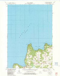
1982 Map of Ellison Bay
USGS Topo · Published 1983About this map
Green Bay and the northern reaches of the Door Peninsula define this 1982 coastal survey, where the rugged shoreline meets the notorious waters of the Great Lakes. The fishing and ferry community of Gills Rock sits at the tip, serving as a gateway for the Ferry route and marking the entrance to Hedgehog Harbor. Southward, the village of Ellison Bay is situated along its namesake bay, bordered by the expansive Ellison Bay Bluff County Park.
Find a feature on this map
30 named features on this map. Tap any name to fly to it.
Don’t see what you’re looking for? This feature index may not catch every label — zoom into the map to look around manually.
Map Details
Editions of this 1982 Ellison Bay Map
This is the sole edition of this map. No revisions or reprints were ever made.
Other maps of this area

1954 · Escanaba
USGS Topo · 1:250,000

1957 · Escanaba
USGS Topo · 1:250,000

1958 · Escanaba
USGS Topo · 1:250,000

1960 · Washington Island
USGS Topo · 1:62,500

1960 · Sister Bay
USGS Topo · 1:62,500

1960 · Ellison Bay
USGS Topo · 1:62,500

1981 · Marinette
USGS Topo · 1:100,000

1982 · Washington Island NW
USGS Topo · 1:24,000
1982 · Washington Island SW
USGS Topo · 1:24,000
1982 · Spider Island
USGS Topo · 1:24,000