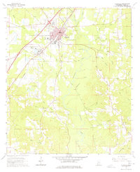
1964 Map of Ellisville
USGS Topo · Published 1978About this map
Ellisville serves as the focal point of this Jones County landscape during the early 1960s, shaped by the Southern RR and a network of small creeks and branches. The town is a significant institutional hub, home to Jones County Junior College and the Ellisville State Sch, along with Roosevelt Sch. Beyond the town limits, the terrain transitions into a mosaic of family-named landmarks and rural congregations like Pleasant Ridge Ch and Tula Rosa Ch. The map records numerous burial grounds, including the Anderson-Minter Cem and the County Home Cem, providing essential data for local genealogical research. Waterways like Tallahala Creek and Rocky Creek dominate the drainage pattern, while scattered industrial sites such as a Gravel Pit and various sandpits suggest the local extractive economy of the mid-century era.
Find a feature on this map
61 named features on this map. Tap any name to fly to it.
Don’t see what you’re looking for? This feature index may not catch every label — zoom into the map to look around manually.
Map Details
Editions of this 1964 Ellisville Map
4 editions found
Other maps of this area

1953 · Hattiesburg
USGS Topo · 1:250,000

1958 · Hattiesburg
USGS Topo · 1:250,000

1963 · Barrontown
USGS Topo · 1:24,000

1964 · Laurel East
USGS Topo · 1:24,000

1964 · Laurel West
USGS Topo · 1:24,000

1964 · Ovett
USGS Topo · 1:24,000

1964 · Ellisville
USGS Topo · 1:24,000

1964 · Lanham
USGS Topo · 1:24,000

1965 · Hebron
USGS Topo · 1:24,000

1965 · Eastabuchie
USGS Topo · 1:24,000