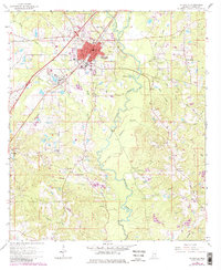
1964 Map of Ellisville
USGS Topo · Published 1982About this map
Ellisville serves as the focal point of this Jones County survey, shown in its mid-century configuration before 1980s updates were added. The town center is densely organized around the Southern railroad line and contains significant institutional landmarks, including Jones County Junior College and the Ellisville State Sch. The surrounding landscape is defined by the diverging paths of Tallahoma Creek and Tallahala Creek, which create a network of bottomlands dotted with rural gathering places like Roosevelt Sch and Pleasant Ridge Ch. Local history is visible in the distribution of family-named landmarks such as the Anderson-Minter Cem and Bynum Cem, while the regional economy is represented by scattered resource extraction sites like the Sandpit and Gravel Pit. The map captures the transition from small-town life to a more connected regional hub as transportation routes evolved around the historic settlement of Tawanta and the County Home.
Find a feature on this map
53 named features on this map. Tap any name to fly to it.
Don’t see what you’re looking for? This feature index may not catch every label — zoom into the map to look around manually.
Map Details
Editions of this 1964 Ellisville Map
4 editions found
Other maps of this area

1953 · Hattiesburg
USGS Topo · 1:250,000

1958 · Hattiesburg
USGS Topo · 1:250,000

1963 · Barrontown
USGS Topo · 1:24,000

1964 · Laurel East
USGS Topo · 1:24,000

1964 · Laurel West
USGS Topo · 1:24,000

1964 · Ovett
USGS Topo · 1:24,000

1964 · Ellisville
USGS Topo · 1:24,000

1964 · Lanham
USGS Topo · 1:24,000

1965 · Hebron
USGS Topo · 1:24,000

1965 · Eastabuchie
USGS Topo · 1:24,000