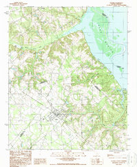
1988 Map of Elloree
USGS Topo · Published 1988About this map
Elloree serves as the primary hub of this landscape where the coastal plain meets the sprawling waters of Lake Marion. The town's grid is clearly defined, situated south of the undulating drainage of Halfway Swamp Creek and west of the expansive Santee State Park. The map reveals a transition from organized agricultural and residential areas to the aquatic environments of the lake, where a boat landing and boat ramp indicate the importance of water access for the local community.
Find a feature on this map
19 named features on this map. Tap any name to fly to it.
Don’t see what you’re looking for? This feature index may not catch every label — zoom into the map to look around manually.
Map Details
Editions of this 1988 Elloree Map
This is the sole edition of this map. No revisions or reprints were ever made.
Other maps of this area

1920 · Eutawville
USGS Topo · 1:48,000

1920 · Bowman
USGS Topo · 1:48,000

1921 · Bowman
USGS Topo · 1:62,500

1921 · Eutawville
USGS Topo · 1:62,500

1943 · Bowman
USGS Topo · 1:62,500

1943 · Orangeburg
USGS Topo · 1:125,000

1943 · Eutawville
USGS Topo · 1:62,500

1946 · Elloree
USGS Topo · 1:62,500

1954 · Augusta
USGS Topo · 1:250,000

1957 · Augusta
USGS Topo · 1:250,000