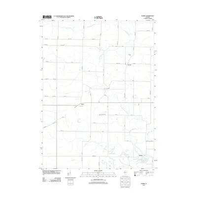
2012 Map of Elmira
USGS Topo · Published 2012About this map
The W Fork Spoon River and its various tributaries, including Jack Cr and Jug Run, define the drainage of this Stark County landscape. This 2012 survey shows the rural agricultural character of the region, anchored by the small unincorporated communities of Elmira, Osceola, and Modena. The local road network is largely structured around a township-and-range grid, with names such as Osceola Rd and N 600 Ave providing access to family farms and local institutions. Genealogists will find the Elmira Cem and Osceola Cem well-documented in their relative positions to the settlements. Unusual landmarks for such a rural area include the Jackson Field Airport and the Allendale Conservation Club Lake located near the southern confluence where the river becomes the main Spoon River.
Find a feature on this map
67 named features on this map. Tap any name to fly to it.
Don’t see what you’re looking for? This feature index may not catch every label — zoom into the map to look around manually.
Map Details
Editions of this 2012 Elmira Map
This is the sole edition of this map. No revisions or reprints were ever made.
Other maps of this area

1921 · Buda
USGS Topo · 1:62,500

1923 · Buda
USGS Topo · 1:62,500

1929 · Annawan
USGS Topo · 1:62,500

1932 · Annawan
USGS Topo · 1:62,500

1933 · Camp Grove
USGS Topo · 1:48,000

1944 · Kewanee
USGS Topo · 1:62,500

1945 · Bradford
USGS Topo · 1:62,500

1958 · Aurora
USGS Topo · 1:250,000

1961 · Aurora
USGS Topo · 1:250,000
1983 · Castleton
USGS Topo · 1:24,000