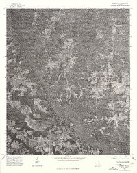
1975 Map of Elmore NE
USGS Topo · Published 1977About this map
Jordan Lake dominates the southwestern portion of this 1975 orthophotoquad, showing the intricate shoreline and surrounding timberland of northern Elmore County during the mid-1970s. This aerial perspective, captured before significant modern development, reveals the agricultural and residential patterns of rural Alabama crossroads. The small community of Holtville sits near the southern bank of the reservoir, while the crossroads of Titus and Buyck serve as the primary landmarks in the more wooded northern and eastern reaches. By utilizing photographic imagery rather than traditional line-drawing, the survey provides a precise view of field boundaries, forest cover, and local infrastructure, which is particularly valuable for researchers tracing the evolution of family lands and rural road networks.
Find a feature on this map
4 named features on this map. Tap any name to fly to it.
Don’t see what you’re looking for? This feature index may not catch every label — zoom into the map to look around manually.
Map Details
Editions of this 1975 Elmore NE Map
This is the sole edition of this map. No revisions or reprints were ever made.
Other maps of this area

1901 · Wetumpka
USGS Topo · 1:125,000

1901 · Wetumpka
USGS Topo · 1:62,500

1903 · Wetumpka
USGS Topo · 1:125,000

1953 · Montgomery
USGS Topo · 1:250,000

1956 · Montgomery
USGS Topo · 1:250,000

1957 · Montgomery
USGS Topo · 1:250,000
1959 · Wetumpka
USGS Topo · 1:62,500

1959 · Elmore
USGS Topo · 1:62,500

1971 · Richville
USGS Topo · 1:24,000
1971 · Mitchell Dam
USGS Topo · 1:24,000