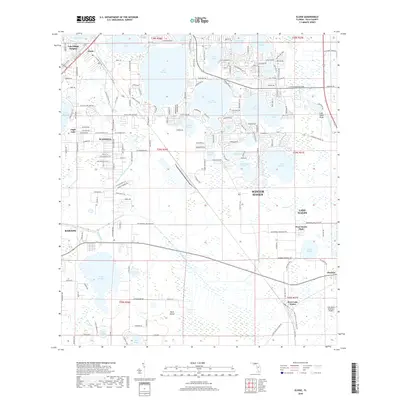
2018 Map of Eloise
USGS Topo · Published 2018About this map
Lake Eloise and Lake Winterset dominate the central landscape of this Polk County survey, illustrating the dense hydrological network of the Florida ridge. The settlement of Wahneta sits west of these waters, characterized by a structured grid of residential streets like 11th Wahneta St W, while the Wahneta Farms Drainage Canal cuts southeast through the terrain toward Peace Creek. To the east, the map captures the transition toward Lake Wales and the infrastructure of the Lake Wales Municipal Airport. Historically significant corridors such as Old Nine Foot Rd and Shell Rd trace earlier transit patterns through the groves and wetlands. The southern reaches are more open, featuring Mule Island and the expansive Lake Garfield, showing the area's characteristic mix of developed lakeside communities and citrus-era drainage works.
Find a feature on this map
183 named features on this map. Tap any name to fly to it.
Don’t see what you’re looking for? This feature index may not catch every label — zoom into the map to look around manually.
Map Details
Editions of this 2018 Eloise Map
This is the sole edition of this map. No revisions or reprints were ever made.
Other maps of this area

1944 · Auburndale
USGS Topo · 1:31,680

1949 · Bartow
USGS Topo · 1:24,000

1950 · Bartow
USGS Topo · 1:24,000

1952 · Homeland
USGS Topo · 1:24,000

1952 · Lake Wales
USGS Topo · 1:24,000

1952 · Babson Park
USGS Topo · 1:24,000

1953 · Dundee
USGS Topo · 1:24,000

1955 · Eloise
USGS Topo · 1:24,000

1955 · Alturas
USGS Topo · 1:24,000

1955 · Orlando
USGS Topo · 1:250,000