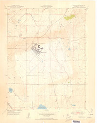
1950 Map of Elsmere
USGS Topo · Published 1950About this map
Peterson Field dominates the central landscape of this El Paso County area, reflecting the military and aviation footprint in Colorado shortly after the war. The airfield, with its runways and support buildings, is situated east of the Chicago Rock Island and Pacific railroad, which cuts diagonally through the northern half of the quadrangle. The small settlement of Elsmere sits along this rail line, serving as a landmark in a territory defined by expansive drainage systems like Sand Creek and Jimmy Camp Creek. To the south, the economy of water management is evident through Big Johnson Reservoir and Little Johnson Res, connected by Canal No 4. The map also captures the Pikes Peak Speedway, providing a look at local recreation and sports infrastructure during this era of mid-century growth.
Find a feature on this map
14 named features on this map. Tap any name to fly to it.
Don’t see what you’re looking for? This feature index may not catch every label — zoom into the map to look around manually.
Map Details
Editions of this 1950 Elsmere Map
2 editions found
Other maps of this area

1893 · Colorado Springs
USGS Topo · 1:125,000

1909 · Colorado Springs
USGS Topo · 1:125,000

1942 · Colorado Springs
USGS Topo · 1:125,000

1948 · Falcon
USGS Topo · 1:24,000

1948 · Colorado Springs
USGS Topo · 1:62,500

1948 · Pikeview
USGS Topo · 1:24,000

1948 · Fountain
USGS Topo · 1:24,000

1948 · Colorado Springs
USGS Topo · 1:24,000

1948 · Cheyenne Mountain
USGS Topo · 1:24,000

1948 · Falcon
USGS Topo · 1:62,500