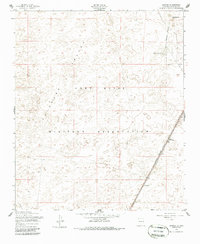
1955 Map of Elwood
USGS Topo · Published 1986About this map
Tularosa Valley terrain dominates this mid-1950s survey of Otero County, where desert expanses meet the logistical infrastructure of the Cold War era. Much of the landscape is occupied by the Fort Bliss Military Reservation, marked by the Military Reservation Boundary that bisects the eastern portion of the sheet. The topographical survey highlights the subtle relief of the basin floor, rising only at Rattlesnake Hill in the northeast corner.
Find a feature on this map
8 named features on this map. Tap any name to fly to it.
Don’t see what you’re looking for? This feature index may not catch every label — zoom into the map to look around manually.
Map Details
Editions of this 1955 Elwood Map
Other maps of this area

1940 · Orogrande
USGS Topo · 1:62,500

1940 · Newman
USGS Topo · 1:62,500

1941 · Desert
USGS Topo · 1:62,500

1943 · Parker Lake
USGS Topo · 1:62,500

1943 · Desert
USGS Topo · 1:62,500

1943 · Newman
USGS Topo · 1:62,500

1943 · Orogrande
USGS Topo · 1:62,500

1947 · Desert NE
USGS Topo · 1:24,000

1947 · Orogrande North
USGS Topo · 1:24,000

1948 · El Wood
USGS Topo · 1:24,000