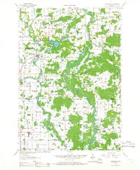
1955 Map of Embarrass
USGS Topo · Published 1966About this map
The Embarrass River and Wolf River dominate this mid-century landscape where agricultural townships meet significant marshlands. The mapping of the 1950s reveals a transition in rural education, marking numerous defunct institutions like the Sunset View Sch and Coffee Bridge Sch. These sites, along with active nodes like the Clintonville Airport, reflect the post-war shifts in local infrastructure.
Find a feature on this map
81 named features on this map. Tap any name to fly to it.
Don’t see what you’re looking for? This feature index may not catch every label — zoom into the map to look around manually.
Map Details
Editions of this 1955 Embarrass Map
2 editions found
Other maps of this area

1954 · Gresham
USGS Topo · 1:48,000

1954 · Shawano
USGS Topo · 1:48,000

1955 · Embarrass
USGS Topo · 1:48,000

1955 · Clintonville
USGS Topo · 1:48,000

1955 · Appleton
USGS Topo · 1:62,500

1955 · Seymour
USGS Topo · 1:62,500

1955 · Green Bay
USGS Topo · 1:250,000

1956 · Gillett
USGS Topo · 1:62,500

1956 · New London
USGS Topo · 1:48,000

1956 · Weyauwega
USGS Topo · 1:48,000