1973 Map of Emerald Lake
USGS Topo · Published 1976About this map
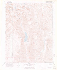
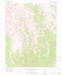
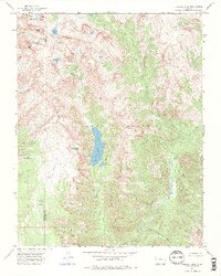
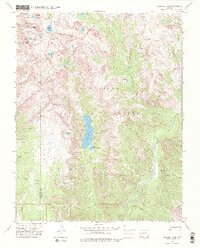
The high-altitude basin of Emerald Lake and the Los Pinos River valley dominate this 1970s survey of the San Juan National Forest. Situated along the border of La Plata and Hinsdale counties, the landscape is defined by its glaciated hydrology and towering peaks. Significant alpine water bodies including Annie Lakes, Betty Lake, and Rock Lake sit at the headwaters of various drainage systems. The map illustrates a network of primitive transportation routes, specifically the Rock Creek Trail, Flint Creek Trail, and various other Pack Trails, which provided the only access into the high country. Landmarks like Mount Oso, Table Mountain, and the curiously named Barebottom Park indicate the area's use by mountaineers and backcountry travelers during this era of conservation and forest management. The presence of Cave Basin and steep canyons like Hell Canyon and Blue Spruce Canyon further illustrate the complex verticality of this part of the Colorado wilderness.
Find a feature on this map
35 named features on this map. Tap any name to fly to it.
Don’t see what you’re looking for? This feature index may not catch every label — zoom into the map to look around manually.
Map Details
Editions of this 1973 Emerald Lake Map
4 editions found
Other maps of this area

1900 · Needle Mountains
USGS Topo · 1:62,500

1902 · Needle Mountains
USGS Topo · 1:62,500

1905 · San Cristobal
USGS Topo · 1:125,000

1907 · San Cristobal
USGS Topo · 1:125,000

1908 · Ignacio
USGS Topo · 1:125,000

1924 · Ignacio
USGS Topo · 1:125,000

1924 · Pagosa Springs
USGS Topo · 1:125,000

1927 · Pagosa Springs
USGS Topo · 1:125,000

1945 · Durango
USGS Topo · 1:250,000

1953 · Durango
USGS Topo · 1:250,000