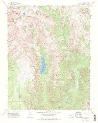
1973 Map of Emerald Lake
USGS Topo · Published 1984About this map
San Juan National Forest defines this high-altitude landscape along the border of La Plata and Hinsdale counties. The central focus is the elongated Emerald Lake, fed by Lake Creek and accompanied by the smaller Little Emerald Lake to its south. The terrain is marked by extreme relief, characterized by prominent summits like Mount Oso and Buffalo Peak, alongside high basins such as Cave Basin and Barebottom Park. This area lacks roads, instead featuring a network of primitive transportation routes labeled as Pack Trail and Trail. These paths connect a series of alpine water bodies, including Flint Lakes, Lake Mary Alice, and Rock Lake, which feed the headwaters of the Los Pinos River and its numerous tributaries like Porcupine Creek and Flint Creek.
Find a feature on this map
37 named features on this map. Tap any name to fly to it.
Don’t see what you’re looking for? This feature index may not catch every label — zoom into the map to look around manually.
Map Details
Editions of this 1973 Emerald Lake Map
4 editions found
Other maps of this area

1900 · Needle Mountains
USGS Topo · 1:62,500

1902 · Needle Mountains
USGS Topo · 1:62,500

1905 · San Cristobal
USGS Topo · 1:125,000

1907 · San Cristobal
USGS Topo · 1:125,000

1908 · Ignacio
USGS Topo · 1:125,000

1924 · Ignacio
USGS Topo · 1:125,000

1924 · Pagosa Springs
USGS Topo · 1:125,000

1927 · Pagosa Springs
USGS Topo · 1:125,000

1945 · Durango
USGS Topo · 1:250,000

1953 · Durango
USGS Topo · 1:250,000