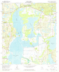
1966 Map of Emeralda Island
USGS Topo · Published 1979About this map
Emeralda Island sits at the heart of this mid-1960s survey, surrounded by the intricate wetlands and marshes of the Oklawaha River system and Lake Griffin. The landscape is a mosaic of hammocks—elevated islands of vegetation such as Bull Hammock and Buck Hammock—interspersed with pumping stations that suggest the ongoing management of this water-dominated terrain. Near the northern boundary, the Ocala National Forest provides a contrast of more stable ground, featuring landmarks like a Lookout Tower and Big Bass Lake.
Find a feature on this map
41 named features on this map. Tap any name to fly to it.
Don’t see what you’re looking for? This feature index may not catch every label — zoom into the map to look around manually.
Map Details
Editions of this 1966 Emeralda Island Map
3 editions found
Other maps of this area

1954 · Daytona Beach
USGS Topo · 1:250,000

1955 · Orlando
USGS Topo · 1:250,000

1957 · Orlando
USGS Topo · 1:250,000

1958 · Orlando
USGS Topo · 1:250,000

1958 · Daytona Beach
USGS Topo · 1:250,000

1962 · Orlando
USGS Topo · 1:250,000

1964 · Daytona Beach
USGS Topo · 1:250,000

1965 · Leesburg East
USGS Topo · 1:24,000

1965 · Umatilla
USGS Topo · 1:24,000

1966 · Leesburg West
USGS Topo · 1:24,000