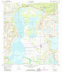
1966 Map of Emeralda Island
USGS Topo · Published 1988About this map
Emeralda Island and the surrounding wetlands of Central Florida are defined by the winding course of the Oklawaha River and the expansive waters of Lake Griffin and Lake Yale. This mid-century landscape is a patchwork of conservation land and small-scale development, where the Ocala National Forest meets localized hubs like Starkes Ferry and Lisbon. The map documents a period of transition, with agricultural hammocks like Bull Hammock and Bell Hammock existing alongside newer infrastructure such as a Landing Strip and Big Trees Campsites. Several named islands, including Big Pine Island and Bird Island, break the surface of the marshy terrain, illustrating the intricate hydrology of the Emeralda Marsh area. Further south, Haines Creek links the major lake systems, supported by various pumping stations that highlight the region's managed water levels.
Find a feature on this map
35 named features on this map. Tap any name to fly to it.
Don’t see what you’re looking for? This feature index may not catch every label — zoom into the map to look around manually.
Map Details
Editions of this 1966 Emeralda Island Map
3 editions found
Other maps of this area

1954 · Daytona Beach
USGS Topo · 1:250,000

1955 · Orlando
USGS Topo · 1:250,000

1957 · Orlando
USGS Topo · 1:250,000

1958 · Orlando
USGS Topo · 1:250,000

1958 · Daytona Beach
USGS Topo · 1:250,000

1962 · Orlando
USGS Topo · 1:250,000

1964 · Daytona Beach
USGS Topo · 1:250,000

1965 · Leesburg East
USGS Topo · 1:24,000

1965 · Umatilla
USGS Topo · 1:24,000

1966 · Leesburg West
USGS Topo · 1:24,000