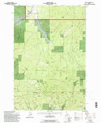
1994 Map of Emida
USGS Topo · Published 1997About this map
Emida stands at the northern edge of this Idaho survey, marking a small pocket of settlement where Santa Creek and Charlie Creek converge. The landscape quickly transitions into the densely wooded slopes of the St Joe National Forest and the peaks of the St Joe Mountains. Topographic detail reveals the complex drainages of the Palouse River and its North Fork, which carve through the southern portion of the quadrangle. Researchers can locate the small Cem just north of Emida and a Gravel Pit along the central creek beds, reflecting the area's local infrastructure. High points like Bald Mountain and Little Bald Mountain dominate the central terrain, while the Benewah and Latah County line tracks across the southern ridges, illustrating the jurisdictional boundaries within the timberlands and mountains.
Find a feature on this map
48 named features on this map. Tap any name to fly to it.
Don’t see what you’re looking for? This feature index may not catch every label — zoom into the map to look around manually.
Map Details
Editions of this 1994 Emida Map
This is the sole edition of this map. No revisions or reprints were ever made.
Other maps of this area

1955 · Pullman
USGS Topo · 1:250,000

1955 · Spokane
USGS Topo · 1:250,000

1957 · Emida
USGS Topo · 1:62,500

1958 · Spokane
USGS Topo · 1:250,000

1958 · Pullman
USGS Topo · 1:250,000

1961 · Deary
USGS Topo · 1:62,500

1961 · Fernwood
USGS Topo · 1:62,500

1961 · Bovill
USGS Topo · 1:62,500

1981 · St Maries
USGS Topo · 1:100,000

1981 · Potlatch
USGS Topo · 1:100,000