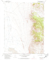
1969 Map of Emigrant Peak
USGS Topo · Published 1982About this map
Emigrant Peak rises sharply over the high desert landscape of central Nevada, anchoring a rugged chain of peaks sliced by numerous named drainages. To the west, the vast Smith Creek Valley (Depression) dominates the terrain, characterized by sparse water sources such as Drumm West Well and Drumm East Well. The geological transition from the valley floor to the summit is marked by a series of steep ravines, including Sand Canyon, Acree Canyon, and Gilbert Canyon. Evidence of early westward travel is preserved in the trace of the Old Overland Road near Smith Creek Summit, where the historical route crosses the southern portion of the quadrangle. This 1969 field check captures the area's isolation and the enduring path of pioneering trails before modern infrastructure altered the primitive road network.
Find a feature on this map
15 named features on this map. Tap any name to fly to it.
Don’t see what you’re looking for? This feature index may not catch every label — zoom into the map to look around manually.
Map Details
Editions of this 1969 Emigrant Peak Map
2 editions found
Other maps of this area

1955 · Millett
USGS Topo · 1:250,000

1959 · Millett
USGS Topo · 1:250,000

1966 · Edwards Creek Valley
USGS Topo · 1:62,500

1969 · Mount Airy
USGS Topo · 1:24,000

1969 · Gandolfo Canyon
USGS Topo · 1:24,000

1969 · Mount Airy Mesa
USGS Topo · 1:24,000

1969 · Emigrant Peak
USGS Topo · 1:24,000

1969 · Dutch Flat
USGS Topo · 1:24,000

1969 · Carroll Summit NE
USGS Topo · 1:24,000

1969 · Iron Mountain
USGS Topo · 1:24,000