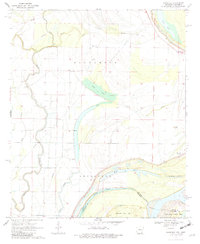
1970 Map of Eminence
USGS Topo · Published 1982About this map
Eminence and Lakeport occupy a landscape deeply defined by the shifting hydrology of the Mississippi River delta in the late 1960s. The terrain is a complex network of bayous and former river channels, including Otter Lake and the winding course of Bayou Macon. This map records the precarious boundary between Arkansas and Mississippi, where the Indefinite Boundary meanders across Kentucky Bend Bar and Island No 88. The importance of water management and river control is evident in the prominent Levee systems and named water features like Moon Chute and Cornfield Chute.
Find a feature on this map
27 named features on this map. Tap any name to fly to it.
Don’t see what you’re looking for? This feature index may not catch every label — zoom into the map to look around manually.
Map Details
Editions of this 1970 Eminence Map
2 editions found
Other maps of this area

1936 · Eudora
USGS Topo · 1:62,500

1936 · Lake Village
USGS Topo · 1:62,500

1939 · Readland
USGS Topo · 1:62,500

1939 · Refuge
USGS Topo · 1:62,500

1953 · Greenwood
USGS Topo · 1:250,000

1955 · Lake Village
USGS Topo · 1:62,500

1956 · Greenwood
USGS Topo · 1:250,000

1957 · Eudora
USGS Topo · 1:62,500
1970 · Glen Allan
USGS Topo · 1:24,000
1970 · Wayside
USGS Topo · 1:24,000