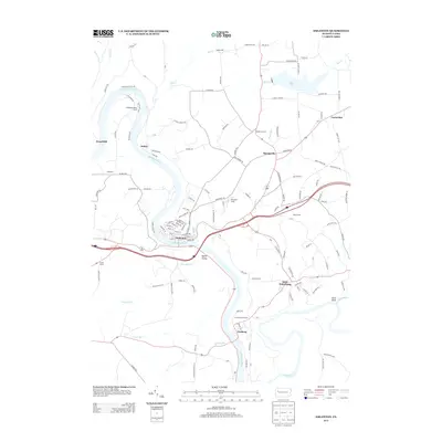
2013 Map of Emlenton
USGS Topo · Published 2013About this map
The Allegheny River carves a deep, winding path through this corner of Venango County, where the historic borough of Emlenton sits at its sharpest bend. The local geography is defined by the confluence of major waterways and the steep elevations rising from the banks, such as the prominent Wood Hill. Downstream, the Clarion River joins the Allegheny near the community of Foxburg, which is noted for its recreational heritage at the Foxburg Golf Course.
Find a feature on this map
136 named features on this map. Tap any name to fly to it.
Don’t see what you’re looking for? This feature index may not catch every label — zoom into the map to look around manually.
Map Details
Editions of this 2013 Emlenton Map
This is the sole edition of this map. No revisions or reprints were ever made.
Other maps of this area

1907 · Foxburg
USGS Topo · 1:62,500

1908 · Foxburg
USGS Topo · 1:62,500

1909 · Franklin
USGS Topo · 1:62,500

1910 · Hilliards
USGS Topo · 1:62,500

1911 · Franklin
USGS Topo · 1:62,500
1912 · Hilliards
USGS Topo · 1:62,500
1922 · Oil City
USGS Topo · 1:48,000
1924 · Oil City
USGS Topo · 1:62,500
1943 · Oil City
USGS Topo · 1:62,500
1944 · Hilliards
USGS Topo · 1:62,500