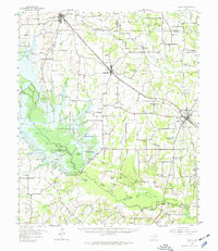
1956 Map of Emory
USGS Topo · Published 1977About this map
Lake Tawakoni dominates the western portion of this landscape, its waters rising behind the Iron Bridge Damsite on the Sabine River. This mid-century survey captures the region as large-scale water management projects were reshaping the Rains County terrain. Numerous rural institutions are scattered across the higher ground, including Clarks Chapel, Bright Star Ch, and the Cody Sch, serving the surrounding agricultural communities of Point, Lone Oak, and Emory.
Find a feature on this map
103 named features on this map. Tap any name to fly to it.
Don’t see what you’re looking for? This feature index may not catch every label — zoom into the map to look around manually.
Map Details
Editions of this 1956 Emory Map
3 editions found
Other maps of this area

1953 · Texarkana
USGS Topo · 1:250,000

1954 · Dallas
USGS Topo · 1:250,000

1954 · Sherman
USGS Topo · 1:250,000

1956 · Texarkana
USGS Topo · 1:250,000

1956 · Tyler
USGS Topo · 1:250,000

1956 · Quinlan
USGS Topo · 1:62,500

1956 · Emory
USGS Topo · 1:62,500

1958 · Dallas
USGS Topo · 1:250,000

1958 · Sherman
USGS Topo · 1:250,000

1958 · Arbala
USGS Topo · 1:24,000