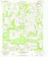
1980 Map of Emory South
USGS Topo · Published 1980About this map
The Sabine River carves a meandering path through the southern half of this landscape, creating a complex wetland network of sloughs and cutoffs. Local drainage patterns are defined by features like Yellow Steer Slough and Little Slough, illustrating the hydrologic character of the border between Rains County and Van Zandt County. On higher ground, the settlement of Emory serves as a primary hub, while rural community life is anchored by locations such as Rocky Point Center and Willow Springs. Cultural landmarks reflecting the area's social history include Smyrna Ch, Dunbar Union Ch, and several family cemeteries such as Woosley Cem and Danley Cem. For genealogists, the map preserves specific burial sites including the notable Trumble Grave. The terrain remains largely rural, dotted with isolated gravel pits and a web of pipelines.
Find a feature on this map
44 named features on this map. Tap any name to fly to it.
Don’t see what you’re looking for? This feature index may not catch every label — zoom into the map to look around manually.
Map Details
Editions of this 1980 Emory South Map
This is the sole edition of this map. No revisions or reprints were ever made.
Other maps of this area

1956 · Tyler
USGS Topo · 1:250,000

1956 · Emory
USGS Topo · 1:62,500

1958 · Arbala
USGS Topo · 1:24,000

1958 · Alba
USGS Topo · 1:24,000

1959 · Grand Saline
USGS Topo · 1:24,000

1959 · Grand Saline
USGS Topo · 1:62,500

1959 · Alba
USGS Topo · 1:62,500
1962 · Edgewood
USGS Topo · 1:24,000
1962 · Fruitvale
USGS Topo · 1:24,000
1980 · Emory North
USGS Topo · 1:24,000