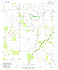
1981 Map of Empire
USGS Topo · Published 1982About this map
Empire sits at the northern edge of this agricultural landscape where the Arkansas and Louisiana borders meet. The terrain is defined by a dense network of watercourses, including the winding Boeuf River and the prominent Bayou Lafourche. These waterways, alongside features like Hubbard Brake and Flat Lake, illustrate the complex drainage patterns of the lower Mississippi Delta region.
Find a feature on this map
18 named features on this map. Tap any name to fly to it.
Don’t see what you’re looking for? This feature index may not catch every label — zoom into the map to look around manually.
Map Details
Editions of this 1981 Empire Map
This is the sole edition of this map. No revisions or reprints were ever made.
Other maps of this area

1909 · Ashton Bridge
USGS Topo · 1:24,000

1912 · Ashton Bridge
USGS Topo · 1:31,680

1935 · Wilmot
USGS Topo · 1:62,500

1935 · Oak Grove
USGS Topo · 1:62,500

1935 · Bonita
USGS Topo · 1:62,500

1936 · Eudora
USGS Topo · 1:62,500

1953 · Greenwood
USGS Topo · 1:250,000

1955 · Jackson
USGS Topo · 1:250,000

1956 · Greenwood
USGS Topo · 1:250,000

1957 · Eudora
USGS Topo · 1:62,500