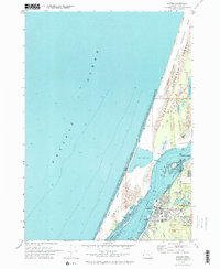
1970 Map of Empire
USGS Topo · Published 1973About this map
Coos Bay dominates this coastal survey, where the bay's waters separate the industrial and residential centers of North Bend and Empire from the shifting terrain of the North Spit. In the early 1970s, the landscape reflects a complex mix of education and industry, anchored by the campus of Southwestern Oregon Community College and a prominent Municipal Airport near the bay's edge. To the west, the Pacific Ocean meets a wide beach backed by the Sand Oregon Dunes National Recreation Area and the Siuslaw National Forest. The map captures specific land-use patterns of the era, from the inland Horsfall Lake and Bluebill Lake to the developed sections of Coos Bay proper, including landmarks like Radar Hill and several local sloughs like Pony Slough and Joe Ney Slough.
Find a feature on this map
31 named features on this map. Tap any name to fly to it.
Don’t see what you’re looking for? This feature index may not catch every label — zoom into the map to look around manually.
Map Details
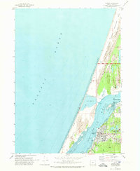
Editions of this 1970 Empire Map
2 editions found
Other maps of this area

1896 · Coos Bay
USGS Topo · 1:125,000

1898 · Coos Bay
USGS Topo · 1:125,000

1900 · Coos Bay
USGS Topo · 1:125,000

1923 · Reedsport
USGS Topo · 1:62,500

1942 · Reedsport
USGS Topo · 1:62,500

1942 · Empire
USGS Topo · 1:62,500

1942 · Coos Bay
USGS Topo · 1:62,500

1944 · Empire
USGS Topo · 1:62,500

1945 · Coos Bay
USGS Topo · 1:62,500

1954 · Coos Bay
USGS Topo · 1:250,000